This paper explores the implications of climate change, vulnerability, adaptation, and their effects on food security, emphasizing challenges like global warming and shifts in climate patterns threatening agricultural productivity. The primary objective of this study is to evaluate climate change impacts on natural resources, communities, sustainable agriculture, and food security, and community livelihood status emphasizing the significance of GIS and remote sensing technologies for understanding and addressing climate change effects. Utilizing a systematic literature review methodology, the study synthesizes findings from various sources to identify effective adaptation strategies. The study discusses various adaptation strategies, including the adoption of climate-resilient crops and sustainable agricultural practices, while considering the importance of community engagement and local knowledge in developing effective interventions. The role of geospatial technology in solving the problem of climate change is highly considered in this review. Additionally, the review delves into the stage of remote sensing in assessing climate change impacts on agriculture and human populations, highlighting the crucial role of remote sensing and GIS in sustainable natural resource conservation and climate change mitigation efforts. The review calls for policymakers, researchers, and practitioners to prioritize climate change adaptation to enhance the resilience of food systems and secure a sustainable future for communities facing the challenges of climate change.
This is an Open Access article, distributed under the terms of the Creative Commons Attribution 4.0 International License (http://creativecommons.org/licenses/by/4.0/), which permits unrestricted use, distribution and reproduction in any medium or format, provided the original work is properly cited.
Climate change refers to the persistent alteration of weather patterns, particularly in tropical regions that has significant impacts on various aspects of our planet, including weather patterns, ecosystems, and human societies
[12]
Abbass, K., Qasim, M. Z., Song, H., Murshed, M., Mahmood, H., & Younis, I. (2022). A review of the global climate change impacts, adaptation, and sustainable mitigation measures. Environmental Science and Pollution Research, 29(2022), 42539–42559.
. Competing challenges facing sustainable agricultural development and food security in the 21st century include climate change, population pressure, and land degradation
[9]
IPCC (2019). Climate Change and Land: an IPCC special report on climate change, desertification, land degradation, sustainable land management, food security, and greenhouse gas fluxes in terrestrial ecosystems [P. R. Shukla, J. Skea, E. Calvo Buendia, V. Masson-Delmotte, H.-O. P¨ortner, D. C. Roberts, P. Zhai, R. Slade, S. Connors, R. van Diemen, M. Ferrat, E. Haughey, S. Luz, S. Neogi, M. Pathak, J. Petzold, J. Portugal Pereira, P. Vyas, E. Huntley, K. Kissick, M. Belkacemi, J. Malley, (eds.)]. In press.
[9]
. This phenomenon is primarily driven by human activities such as the burning of fossil fuels (coal, oil, natural gas) and extensive deforestation, leading to increased levels of greenhouse gases (GHGs) in the atmosphere. These changes have resulted in rapid shifts in global temperature and precipitation patterns over the past century
[2]
Bekele Tona Amenu Barena Adare Amamo Teshome Tadewos Borko (2017). Review on Climate Change Adaptation and Mitigation Mechanisms in Ethiopia. Civil and Environmental Research, ISSN 2224-5790 (Paper) ISSN 2225-0514, Vol. 9, No. 12, 2017.
[2]
. Recognized as a global threat, climate change is beginning to strain various industries worldwide
[12]
Abbass, K., Qasim, M. Z., Song, H., Murshed, M., Mahmood, H., & Younis, I. (2022). A review of the global climate change impacts, adaptation, and sustainable mitigation measures. Environmental Science and Pollution Research, 29(2022), 42539–42559.
. Global warming and observed climate changes in the 21st century represent significant global shifts that have occurred over the past 65 years
[12]
Abbass, K., Qasim, M. Z., Song, H., Murshed, M., Mahmood, H., & Younis, I. (2022). A review of the global climate change impacts, adaptation, and sustainable mitigation measures. Environmental Science and Pollution Research, 29(2022), 42539–42559.
Adger WN, Arnell NW, Tompkins EL (2005) Successful adaptation to climate change across scales. Glob Environ Chang 15(2): 77–86.
[12, 1]
. To comprehensively understand past, present, and future climate scenarios and other biophysical systems at various scales, extensive long-term data collection is essential
. Sub-Saharan Africa has notably experienced temperature increases, as reported by the Intergovernmental Panel on Climate Change
[9]
IPCC (2019). Climate Change and Land: an IPCC special report on climate change, desertification, land degradation, sustainable land management, food security, and greenhouse gas fluxes in terrestrial ecosystems [P. R. Shukla, J. Skea, E. Calvo Buendia, V. Masson-Delmotte, H.-O. P¨ortner, D. C. Roberts, P. Zhai, R. Slade, S. Connors, R. van Diemen, M. Ferrat, E. Haughey, S. Luz, S. Neogi, M. Pathak, J. Petzold, J. Portugal Pereira, P. Vyas, E. Huntley, K. Kissick, M. Belkacemi, J. Malley, (eds.)]. In press.
[9]
. While warming trends aren’t uniform across the region, there is a noticeable increase in warm spells and a decrease in extremely cold days.
Understanding the impacts of climate change, vulnerabilities, and adaptive responses at local levels is crucial for devising effective adaptation strategies within communities and farms. The review emphasizes the significance of accurately documenting and analyzing climate change patterns and trends to propose mitigation mechanisms. Utilizing advanced tools like GIS and remote sensing is essential for addressing climate change challenges. The review delves into the socio-scientific aspects of climate change effects on various sectors globally, particularly on food security, agriculture, biodiversity, health, economy, forestry, and tourism. It discusses practical mitigation strategies and adaptation practices, focusing on economic, social, and environmental aspects. The review also highlights the importance of data collection methodologies and the role of GIS and remote sensing in analyzing climate change impacts and implementing sustainable solutions.
2. Review Methodology
This study employed a systematic literature review that aimed to detect climate change, mitigation and adaptation for sustainable food security, identify existing gaps using GIS and remotely sensed data as well as their effects on sustainable development. The review also aimed to further outline the strength and limitation associated with remote sensing applications for predicting and monitoring the impacts of climate change, mitigation and adaptation for sustainable food security.
3. Widely Used GIS and Remote Sensing Algorithms
Geographic information systems (GIS) and modeling have become critical tools in climate change detection, drought and research on natural resource management (NRM), yet their utilization is minimal and inadequate
[7]
Gizachew Legesse & K. V. Suryabhagavan (2014). Remote Sensing and GIS Based Agricultural Drought Assessment in East Shewa Zone, Ethiopia. Tropical Ecology 55(3): 349-363, 2014 Issn 0564-3295.
[7]
. Utilization of GIS spatial-interpolation techniques such as inverse distance weighted (IDW), NDVI and Spline and Kriging interpolation techniques are some of the ArcGIS application tools essential for data reconstruction. To aid in understanding spatiotemporal occurrence and patterns of agro-climatic variables (e.g., rainfall), accurate and inexpensive quantitative approaches such as GIS modeling and availability of long-term data are essential. Most meteorological data in the study area are inconsistent, unrecorded, or missing, leading to more discrete and unreliable datasets for analysis. Besides the main stations themselves being several kilometers from the target area.
4. Methods of Literature Search and Data Extraction
Today we live in a virtual digital world where climate change has a major impact
[10]
Suryabhagavan, K. V. (2017). GIS-based climate variability and drought characterization in Ethiopia over three decades. Weather and Climate Extremes. Retrieved from
. The current focus is on remote sensing systems, disaster management, development of forecasting systems and spatial data analysis as the main tools for problem solving. Technological advances have significantly improved the provision of data to users, with the global movement of Earth observation satellites demonstrating characteristics in various applications
[16]
Nayak, S., & Zlatanova, S. (2008). Remote Sensing and GIS Technologies for Monitoring and Prediction of Disasters. In S. E. R. A. U. F. W. Salomons (Ed.), Environmental Science and Engineering.
[16]
. Remote sensing technology is now widely used to monitor climate change at different scales, especially in regions where land observation is limited and challenging. This review aims to examine the current state of research on climate change impacts, adaptation and mitigation strategies, drawing on published and unpublished studies, while focusing on the role of GIS and remote sensing.
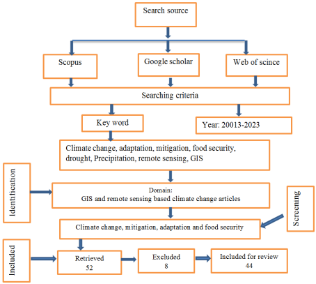
In the literature search, Google Scholar, Scopus and Web of Science databases were used, focusing on international peer-reviewed journals in the fields of remote sensing, climate change mitigation, adaptation, food security and information systems. Search strategies include defining appropriate search terms and identifying key words, phrases, and terms. To identify relevant keywords, phrases and terms, I used the most cited literature reviews. Initial searches included terms such as Climate change; Perceptions; Adaptation, Food security, and Drought”, resulting in a total of 52 publications being retrieved (22 from Google Scholar, 20 from Scopus, and 20 from Web of Science) and finally forty four (44) articles were selected for review. Accordingly, application of remote sensing and GIS in agriculture and natural resource management under changing climatic conditions
[17]
p k kingra, debjyoti majumder and som pal singh,(2016), application of Remote Sensing and GIS in agriculture and natural resource management under changing climatic conditions. school of climate change and agricultural meteorology punjab agricultural university, ludhiana – 141 004.
one which get more consideration. Therefore, the remote use of GIS in agriculture and natural resource management has been investigated in the context of climate change
[17]
p k kingra, debjyoti majumder and som pal singh,(2016), application of Remote Sensing and GIS in agriculture and natural resource management under changing climatic conditions. school of climate change and agricultural meteorology punjab agricultural university, ludhiana – 141 004.
for easily acquiring data from very challenging (desert, malaria prone area,) environmental condition. GIS methods and remote sensing play a lion share to monitor climate change – land degradation to support conservation tools and planning
[14]
Marzia Gabriele, Raffaella Brumana, Mattia Previtali and Alberta Cazzani, (2022). A combined GIS and remote sensing approach for monitoring climate change‑related land degradation to support landscape preservation and planning tools: the Basilicata case study. Applied Geomatics (2023) 15: 497–532
GIS-based mapping and mapping of climate-sensitive airfields in Addis Ababa
[16]
Nayak, S., & Zlatanova, S. (2008). Remote Sensing and GIS Technologies for Monitoring and Prediction of Disasters. In S. E. R. A. U. F. W. Salomons (Ed.), Environmental Science and Engineering.
[16]
to identify the degree of flooding. The study indicates that, Addis Ababa was drastically suffering most of the time by frequent flooding due to environmental degradation
[10]
Suryabhagavan, K. V. (2017). GIS-based climate variability and drought characterization in Ethiopia over three decades. Weather and Climate Extremes. Retrieved from
Nathaniel Bayode Eniolorunda (2014), Climate Change Analysis and Adaptation: The Role of Remote Sensing (Rs) a nd Geographical Information System (Gis), International Journal of Computational Engineering Research (ijceronline.com) Vol. 04 Issue. 01,
The review is mainly aimed to analyze and show the impact of climate change on environment and population food security status. To depict clearly the degree of severity and magnitude of climate change and food security, I tried to analyze and compare the significance level of GIS and remote sensing as well as the widely used algorithms in papers under consideration.
Table 1. Widely used Geospatial tools in the reviewed articles.
No
Data
Sensor used
To detect
Reference
1
Synthetic Aperture Radar (SAR)
LANDSAT
emissions, mitigation, impacts, and adaptation
[11]
Karen C. Seto and Peter Christensen (2013), Remote sensing science to inform urban climate change mitigation strategies. Urban Climate 3 (2013) 1–6/
soil fertility, property and agricultural risk management, flood detection, NR management
[13]
M. T. Esetlili, et. Al (2018). Remote Sensing and Geographic Information System in the Management of Agricultural Risks Related to Climate Change. Journal of Environmental Protection and Ecology 19, No 3, 1293–1306 (2018).
Marzia Gabriele, Raffaella Brumana, Mattia Previtali and Alberta Cazzani, (2022). A combined GIS and remote sensing approach for monitoring climate change‑related land degradation to support landscape preservation and planning tools: the Basilicata case study. Applied Geomatics (2023) 15: 497–532
Nathaniel Bayode Eniolorunda (2014), Climate Change Analysis and Adaptation: The Role of Remote Sensing (Rs) a nd Geographical Information System (Gis), International Journal of Computational Engineering Research (ijceronline.com) Vol. 04 Issue. 01,
trend detection in rainfall, weather events and drought characterization
[10]
Suryabhagavan, K. V. (2017). GIS-based climate variability and drought characterization in Ethiopia over three decades. Weather and Climate Extremes. Retrieved from
Marzia Gabriele, Raffaella Brumana, Mattia Previtali and Alberta Cazzani, (2022). A combined GIS and remote sensing approach for monitoring climate change‑related land degradation to support landscape preservation and planning tools: the Basilicata case study. Applied Geomatics (2023) 15: 497–532
p k kingra, debjyoti majumder and som pal singh,(2016), application of Remote Sensing and GIS in agriculture and natural resource management under changing climatic conditions. school of climate change and agricultural meteorology punjab agricultural university, ludhiana – 141 004.
Source: Remotely sensed data used in reviewed articles.
6. Observed Shortcomings, Strengths and Solutions
In some of the reviewed articles, provided comprehensive assessment of climate variability documenting historical extreme climate events at zonal and regional scales as well as assessed historical drought events and implications of drought response capacity was considered as strength
[13]
M. T. Esetlili, et. Al (2018). Remote Sensing and Geographic Information System in the Management of Agricultural Risks Related to Climate Change. Journal of Environmental Protection and Ecology 19, No 3, 1293–1306 (2018).
[13]
. Providing a detailed explanation of the methodology, including the collection of soil and plant spectral data, analysis techniques, and mapping of soil productivity groups, the practical application of remote sensing and GIS in agricultural risk management, showing how these technologies can be used to assess soil productivity and monitor agricultural areas
[13]
M. T. Esetlili, et. Al (2018). Remote Sensing and Geographic Information System in the Management of Agricultural Risks Related to Climate Change. Journal of Environmental Protection and Ecology 19, No 3, 1293–1306 (2018).
[13]
are some issues seen as strength of the paper. In the same way, by integrating two climate vulnerability models for comprehensive analysis, identified vulnerable sub-cities in Addis Ababa based on 15 indicators and analyzes exposure layers like temperature changes and flood risks
[17]
p k kingra, debjyoti majumder and som pal singh,(2016), application of Remote Sensing and GIS in agriculture and natural resource management under changing climatic conditions. school of climate change and agricultural meteorology punjab agricultural university, ludhiana – 141 004.
Nathaniel Bayode Eniolorunda (2014), Climate Change Analysis and Adaptation: The Role of Remote Sensing (Rs) a nd Geographical Information System (Gis), International Journal of Computational Engineering Research (ijceronline.com) Vol. 04 Issue. 01,
and climate change relationships, and identified key opportunities for remote sensing science in urban climate research and offers a view of urban patterns across multiple scales. In most of the reviewed article, comprehensive insights on climate change and key opportunities for remote sensing science in climate research were discussed
[6]
Feyissa, G., Zeleke, G., Gebremariam, E., & Bewket, W. (2018). GIS-based quantification and mapping of climate change vulnerability hotspots in Addis Ababa. Geoenvironmental Disasters.
Suryabhagavan, K. V. (2017). GIS-based climate variability and drought characterization in Ethiopia over three decades. Weather and Climate Extremes. Retrieved from
The papers reviewed offer a detailed examination of the impact of global warming on agriculture and emphasize the significance of remote sensing technology in crop monitoring and management, including the estimation of crop parameters and vegetation status
[13]
M. T. Esetlili, et. Al (2018). Remote Sensing and Geographic Information System in the Management of Agricultural Risks Related to Climate Change. Journal of Environmental Protection and Ecology 19, No 3, 1293–1306 (2018).
[14]
Marzia Gabriele, Raffaella Brumana, Mattia Previtali and Alberta Cazzani, (2022). A combined GIS and remote sensing approach for monitoring climate change‑related land degradation to support landscape preservation and planning tools: the Basilicata case study. Applied Geomatics (2023) 15: 497–532
Nayak, S., & Zlatanova, S. (2008). Remote Sensing and GIS Technologies for Monitoring and Prediction of Disasters. In S. E. R. A. U. F. W. Salomons (Ed.), Environmental Science and Engineering.
[13, 14, 16]
. While the strengths of the research are acknowledged, limitations such as the need to consider external factors like socio-economic conditions, pest infestations, and climate variability are highlighted to provide a more comprehensive understanding of soil productivity and agricultural risks due to climate change. Addressing these limitations through collaboration with experts from relevant fields is suggested to enhance the analysis. Identified gaps include the lack of in-depth analysis on the accuracy and reliability of remote sensing data in real-world applications.
The review points out the limited focus on the economic implications of vulnerability assessments, the absence of detailed discussions on specific adaptation strategies, and the lack of specific examples for interdisciplinary research collaborations
[10]
Suryabhagavan, K. V. (2017). GIS-based climate variability and drought characterization in Ethiopia over three decades. Weather and Climate Extremes. Retrieved from
p k kingra, debjyoti majumder and som pal singh,(2016), application of Remote Sensing and GIS in agriculture and natural resource management under changing climatic conditions. school of climate change and agricultural meteorology punjab agricultural university, ludhiana – 141 004.
. Additionally, there is a scarcity of detailed discussions on the challenges encountered in urban climate studies
[15]
Nathaniel Bayode Eniolorunda (2014), Climate Change Analysis and Adaptation: The Role of Remote Sensing (Rs) a nd Geographical Information System (Gis), International Journal of Computational Engineering Research (ijceronline.com) Vol. 04 Issue. 01,
, specific case studies, and practical applications, with potential areas of remote sensing and GIS applications not fully explored. The implementation of strategic adaptation measures using GIS spatial-interpolation techniques for data analysis is highlighted as an effective approach to address climate variability and extreme weather events. Prioritizing agricultural research and natural resource management based on vulnerability assessment outcomes should be emphasized to enhance mitigation and adaptation efforts in response to climate change for sustainable food security.
7. The Impacts of Climate Change
The ever-increasing emissions of greenhouse gases from various sources have led to catastrophic climate changes including the well pronounced ‘global warming’
[20]
S. VijayaVenkataRaman, S., Iniyan, S., & Ranko Goic. (2011). A review of climate change, mitigation and adaptation. Renewable and Sustainable Energy Reviews, 16(2012), 878–897.
[20]
. Natural and environmental disasters due to climate change can be highly variable from year to year; some years pass with very few deaths before a significant disaster event claims many lives
[21]
Symanski, E., Han, H. A., Han, I., McDaniel, M., Whitworth, K. W., McCurdy, S., Delclos, G. L. (2021). Responding to natural and industrial disasters: partnerships and lessons learned. Disaster Medicine and Public Health Preparedness, 1–4.
[21]
. Climate change poses serious and interconnected threats to the environment, human health, and natural resources. The assessment of climate change’s impacts on biophysical systems is a highly complex area of research wherein remote-sensing technologies are widely used to evaluate the changes in these systems over time
Environmental impacts such as the loss of biodiversity due to disrupted habitats and extreme weather events, as well as sea level rise, which threatens coastal ecosystems and communities, became a threat over the globe. Human health is at risk from heat-related illnesses, increased disease transmission, and worsened air quality. Natural resources are affected by water scarcity, diminished agricultural productivity, and the loss of ecosystem services such as clean water and pollination. These impacts not only endanger ecosystems and species but also jeopardize human well-being and economic stability, emphasizing the urgent need for comprehensive mitigation and adaptation efforts to address the multifaceted challenges of climate change. In order to identify the degree of climate change impact and striving to find the solution modern technology (remote sensing and GIS) play crucial role.
7.1. Flood Monitoring
Satellite remote sensing allows timely investigation for large regions and provides frequent imaging of the region of interest. Until recently, near real-time flood detection was not possible, but with sensors such as Hyperion on board the EO-1 satellite, this has been significantly improved. Automated spacecraft technology has reduced the time to detect and react to flood events in a few hours
[5]
Felipe, I. P., Dohm, J. M., Baker, V. R., Doggett, T., Davies, A. G., Castano, R., Chien, S., Cichy, B., Greeley, R., Sherwood, R., Tran, D., & Rabideau, G. (2006). Flood detection and monitoring with the autonomous sciencecraft experiment onboard EO-1. Remote Sensing of Environment, 101, 463-481.
[5]
. Most recent studies from NASA and the US Geological Survey are utilizing satellite observations of rainfall, rivers and surface topography into early warning systems by employing satellite microwave sensors to gauge discharge from rivers by measuring changes in river widths and satellite based estimates of rainfall to improve warning systems
[3]
Brackenridge R, Anderson E and Nghiem S V (2006). Satellite microwave detection and measurement of river floods. NASA Spring Annual General Conference 2006.
Glaber, C., & Reinartz, P. (2004). Multitemporal and multispectral remote sensing approach for flood detection in the Elbe-Mulde region. Acta Hydrochimica et Hydrobiologica.
[8]
, detected flooded areas with satellite data and investigated moisture classes in flood plain areas in relation to water changes, accumulation of sediments and silts for different land-use classes and erosive impacts of floods. According to
[19]
Roux, H., & Dartus, D. (2006). Use of parameter optimization to estimate a flood wave: potential applications to remote sensing of rivers. Journal of Hydrology.
[19]
estimated discharge and flood hydrographs from hydraulic information obtained from remotely sensed data. Optimization methods were also used to minimize discrepancies between simulations and observations of flood extent fields to estimate river discharge.
7.2. Drought
In almost every part of the world, drought is a normal part of the climate and a slow-onset, creeping natural hazard that has detrimental effects on the environment, society, and economy
[18]
Parul Chopra, (2006), drought risk assessment using remote sensing and GIS: a case study of Gujarat. Indian institute of remote sensing, national remote sensing agency (NRSA), MA. Thesis.
[18]
. Determining the beginning and end of a drought, as well as its intensity, can be challenging. One unpredictable natural disaster that can have a negative impact on human life is drought. Another way to think of drought is as a shortage of water supply relative to what is needed for human needs
[4]
Chapman L and Thornes J E (2003). The use of geographical information system in Climatology and meteorology. Climate and Atmospheric Research Group, School of Geography and Environmental Science, University of Birmingham, Birmingham B15 2TT, UK.
[4]
. The most harmful natural disaster is drought, which has an impact on many facets of society including agriculture, ecosystem services, human health, recreation, and water resources. It has been a part of the climate, and it has affected many countries in the world. Frequent drought is an important aspect of climate variability and climate change that humans have been experiencing in recent decades
[18]
Parul Chopra, (2006), drought risk assessment using remote sensing and GIS: a case study of Gujarat. Indian institute of remote sensing, national remote sensing agency (NRSA), MA. Thesis.
[18]
.
Drought, also known as agricultural drought elsewhere, is the result of the seasonal rains (June to September in Ethiopian context) failing, which results in the loss of crops and cattle. In addition to major food shortages in households, the loss of crops and animals frequently results in psychological distress and insecurity in the affected individuals. Climate variability is a major factor in the failure of seasonal rainfall (meteorological drought), which results in significant livestock losses in pastoralist areas, widespread failure of seasonal crops, pasture, and fodder, and severe famine among the affected population. Therefore, using remote sensing NDVI deviation map from normal year to drought year, it is possible to calculate the percentage of drought affected area by drought risk level and show the effectiveness of satellite derived drought indices as an indicator for drought risk assessment and identifying the most draught vulnerable area.
8. Discussion
The use of remote sensing and GIS in identifying the problems caused by any natural and man-made disasters to the environment and human helps to solve a complex problems in an appropriate way. In this regard
[13]
M. T. Esetlili, et. Al (2018). Remote Sensing and Geographic Information System in the Management of Agricultural Risks Related to Climate Change. Journal of Environmental Protection and Ecology 19, No 3, 1293–1306 (2018).
[13]
used Sentinel-2 satellite type to detect the management of agricultural risks related to climate change and a total of 16 Sentinel-2 satellite images were examined, collected between March 2018 and August 2018. The authors used Images from June particularly for interpreting soil covering characteristics, leaf density, and reflection characteristics for improving soil productivity groups.
From this point of view, we critically understand the utilization of remote sensing and geographic information systems (GIS) in managing agricultural risks related to climate change has a significant advantage. The study conducted by
[13]
M. T. Esetlili, et. Al (2018). Remote Sensing and Geographic Information System in the Management of Agricultural Risks Related to Climate Change. Journal of Environmental Protection and Ecology 19, No 3, 1293–1306 (2018).
[13]
and colleagues focuses on monitoring agricultural areas, assessing soil productivity, and predicting potential damages to crops using advanced technologies such as remote sensing and GIS had significant implication.
The study conducted by
[14]
Marzia Gabriele, Raffaella Brumana, Mattia Previtali and Alberta Cazzani, (2022). A combined GIS and remote sensing approach for monitoring climate change‑related land degradation to support landscape preservation and planning tools: the Basilicata case study. Applied Geomatics (2023) 15: 497–532
utilized a combined approach involving GIS and remote sensing technology. For remote sensing, the study used Normalized Difference Vegetation Index (NDVI) differencing to evaluate changes in vegetation cover over a 20-year period (2000-2020). Atmospheric correction and noise removal were performed using the Semi-Automatic Classification Plugin in QGIS 3.8. The NDVI images were processed to identify areas of probable land degradation based on changes in vegetation cover. The GIS approach involved implementing six main indicators (Soil Quality Index, Climate Quality Index, Vegetation Quality Index, Management Quality Index, Landslide Risk Index, and Water Availability Index) at the regional scale, following the MEDALUS approach. This allowed for the assessment of sensitivity to degradation at both regional and mid-regional scales.
The study conducted by
[17]
p k kingra, debjyoti majumder and som pal singh,(2016), application of Remote Sensing and GIS in agriculture and natural resource management under changing climatic conditions. school of climate change and agricultural meteorology punjab agricultural university, ludhiana – 141 004.
delves into the utilization of various satellite technologies and image processing methods to monitor agricultural productivity and environmental changes. By employing MODIS and AVHRR satellite types, the research captures vegetation indices, enabling the estimation of evapotranspiration and monitoring of crop yield variations. Additionally, Synthetic Aperture Radar (SAR) data is utilized for biomass quantification in wetlands, showcasing the sensitivity of SAR signals to changes in biomass. Through time-series analysis of remote sensing images, alterations in vegetation cover and composition in arid lands are detected. Moreover, hyper spectral imagery is leveraged to estimate canopy characteristics, plant density, leaf area index, and chlorophyll content, providing valuable insights for agricultural management and environmental monitoring.
The study underscores the profound impact of remote sensing technology in revolutionizing environmental management practices, especially in addressing challenges posed by climate change. It emphasizes the critical role of timely and repetitive data from remote sensing in facilitating informed decision-making and sustainable resource utilization. The integration of remote sensing and GIS in precision agriculture and forestry allows for accurate estimation of plant properties, vegetation monitoring, and the prediction of water stress across extensive areas. Despite the recognized benefits in crop monitoring and stress detection, the study acknowledges existing challenges in effectively harnessing these technologies for optimal resource management in evolving climates. This highlights the necessity for further research and development to fully exploit remote sensing and GIS for sustainable agriculture and natural resource management in changing environmental conditions.
As
[15]
Nathaniel Bayode Eniolorunda (2014), Climate Change Analysis and Adaptation: The Role of Remote Sensing (Rs) a nd Geographical Information System (Gis), International Journal of Computational Engineering Research (ijceronline.com) Vol. 04 Issue. 01,
mentioned the use of satellite data from various sources, including NOAA Advanced Very High Resolution Radiometer (AVHRR), Landsat, SPOT, Radar Sat, and satellite instruments such as the global ozone monitoring experiment (GOME) flight model (FM) Satellite spectrometer, Atmospheric Infrared Sounder (AIRS), Advanced Microwave Sounder Unit (AMSU), and Advanced Microwave Scanning Radiometer for EOS (AMSRE). These satellites are used for measuring atmospheric dynamics, monitoring glaciers, assessing drought and flood impact, and detecting and assessing drought conditions.
The study by
[11]
Karen C. Seto and Peter Christensen (2013), Remote sensing science to inform urban climate change mitigation strategies. Urban Climate 3 (2013) 1–6/
utilizes state-of-the-art of GIS and remote sensing techniques to investigate the relationship between urban systems and climate change mitigation strategies. Some key aspects of GIS and remote sensing satellite types commonly used in urban remote sensing studies include Landsat, Sentinel, and MODIS. These satellites provide high-resolution imagery and data for monitoring urban areas over time by acquired through satellite imagery. Multispectral imagery was used to capture information about urban form, land cover, and land use patterns. Optical imagery was used for land cover classification, urban form analysis, and monitoring changes in urban areas where as Land cover datasets by integrated into GIS analysis to understand emissions trajectories and mitigation potential scale.
GIS modeling and availability of long- term data are highlighted as essential for understanding spatiotemporal patterns of agro-climatic variables like rainfall
[12]
Abbass, K., Qasim, M. Z., Song, H., Murshed, M., Mahmood, H., & Younis, I. (2022). A review of the global climate change impacts, adaptation, and sustainable mitigation measures. Environmental Science and Pollution Research, 29(2022), 42539–42559.
. Emphasizing the importance of accurate and inexpensive quantitative approaches facilitated by GIS and remote sensing for assessing climate variability and drought characterization in Ethiopia, GIS spatial- interpolation techniques such as IDW, Spline, and Kriging was used for data reconstruction in the study area.
The impact of climate change on water resources in the Awash River Basin, Ethiopia, and temperature and rainfall extremes in the Yellow River source region, China was reviewed. It also discusses the influence of global climate change on infectious diseases such as cholera. Moreover, the study addresses the ramifications of climate change on agricultural activities, crop yields, and food security in Africa. Findings reveal a significant warming trend over the last three decades, with maximum, minimum, and mean temperatures consistently rising. Additionally, the study underscores the repercussions of droughts on various sectors, including the economy, and stresses the importance of regional drought monitoring and prediction utilizing remotely sensed data.
By harnessing spatially explicit and synoptic views of urban landscapes provided by remote sensing technology, the researchers identified key opportunities to enhance our understanding of the intricate relationships between urban systems and climate change. Through the analysis of historical urban form using Landsat data archives spanning over 40 years,
[11]
Karen C. Seto and Peter Christensen (2013), Remote sensing science to inform urban climate change mitigation strategies. Urban Climate 3 (2013) 1–6/
highlighted the significance of government policies and incentives in shaping carbon-intensive land uses. Remote sensing data not only facilitated the evaluation of urban expansion patterns but also enabled the examination of the conversion of land covers driven by terrestrial space demand and raw material requirements which its extraction may factor climate change. Furthermore, the study underscored the vulnerability of urban infrastructure to extreme climate events and the importance of combining satellite-derived risk analysis with geographical models to understand regional and global patterns of urban climate adaptation. Therefore, interdisciplinary collaborations among remote sensing scientists, economists, architects, planners, and climate modelers to advance analyses crucial for effective urban climate change mitigation strategy are recommended.
The study conducted by
[14]
Marzia Gabriele, Raffaella Brumana, Mattia Previtali and Alberta Cazzani, (2022). A combined GIS and remote sensing approach for monitoring climate change‑related land degradation to support landscape preservation and planning tools: the Basilicata case study. Applied Geomatics (2023) 15: 497–532
utilized a combined approach involving GIS and remote sensing. For remote sensing, the study used Normalized Difference Vegetation Index (NDVI) differencing to evaluate changes in vegetation cover over a 20-year period (2000-2020). Atmospheric correction and noise removal were performed using the Semi-Automatic Classification Plugin in QGIS 3.8. The NDVI images were processed to identify areas of probable land degradation based on changes in vegetation cover. The GIS approach involved implementing six main indicators (Soil Quality Index, Climate Quality Index, Vegetation Quality Index, Management Quality Index, Landslide Risk Index, and Water Availability Index) at the regional scale, following the MEDALUS approach. This allowed for the assessment of sensitivity to degradation at both regional and mid-regional scales. The impact of climate change on the Mediterranean region, particularly in the Basilicata Region was analyzed
[14]
Marzia Gabriele, Raffaella Brumana, Mattia Previtali and Alberta Cazzani, (2022). A combined GIS and remote sensing approach for monitoring climate change‑related land degradation to support landscape preservation and planning tools: the Basilicata case study. Applied Geomatics (2023) 15: 497–532
. It emphasized the region's vulnerability to land degradation stresses and desertification phenomena due to factors such as soil erosion, salinization, and loss of organic carbon, loss of biodiversity, landslides, deforestation, depopulation, and wildfires. The research aimed to provide evidence-based data for integrated landscape planning strategies in marginal territories to address these climate change impacts.
A study conducted by
[6]
Feyissa, G., Zeleke, G., Gebremariam, E., & Bewket, W. (2018). GIS-based quantification and mapping of climate change vulnerability hotspots in Addis Ababa. Geoenvironmental Disasters.
on climate change vulnerability hotspots in Addis Ababa by using Landsat to obtain Land surface temperature change layer, bio-physical, socio-economic, and geographic factors determine vulnerability to climate change, specifically focusing on flooding and urban heat impacts in identified cities.
GIS and remote sensing significantly aided in assessing climate change vulnerability by offering advanced tools and methods. GIS assigned raster image values to sub-cities, computed zonal statistics, and analyzed land surface temperature variations over time and elevation. Remote sensing, using Landsat satellite images, provided data on land surface temperature changes. Moreover, GIS integrated slope data with historical flood information from the Addis Ababa fire and emergency preparedness office, enabling a thorough flood risk analysis in the region.
9. Conclusion
In summary, the main objective of the review was to rate the effects of climate change on environmental management, sustainable agricultural development and food security. It emphasizes the challenges posed by climate change and the importance of using GIS and remote sensing technologies to understand and mitigate its impacts. The study also reviews various studies that have utilized GIS and remote sensing in analyzing climate change and its effects on sectors like agriculture, biodiversity, health, economy, forestry, and tourism. It concludes by discussing the benefits of using remote sensing and GIS in managing agricultural risks related to climate change and establishing databases for natural resource conservation purposes.
Abbreviations
GIS
Geographic Information System
EO
Earth Observation
MEDALUS
Mediterranean Desertification and Land Use
NRM
Natural Resource Management
Author Contributions
Terefe Hundessa: Conceptualization, Data curation, Formal article Investigation, Writing – original draft, Writing – review & editing
Bahailu Getu: Conceptualization, Data curation, Writing – review & editing
Acknowledgments
The first author expresses gratitude to Dr. Asnake Mekuriaw for his technical and methodological supports.
Funding
This review article received no specific support from public, commercial, or non-profit funding entities.
Conflicts of Interest
The authors declare no conflicts of interest.
References
[1]
Adger WN, Arnell NW, Tompkins EL (2005) Successful adaptation to climate change across scales. Glob Environ Chang 15(2): 77–86.
[2]
Bekele Tona Amenu Barena Adare Amamo Teshome Tadewos Borko (2017). Review on Climate Change Adaptation and Mitigation Mechanisms in Ethiopia. Civil and Environmental Research, ISSN 2224-5790 (Paper) ISSN 2225-0514, Vol. 9, No. 12, 2017.
[3]
Brackenridge R, Anderson E and Nghiem S V (2006). Satellite microwave detection and measurement of river floods. NASA Spring Annual General Conference 2006.
Chapman L and Thornes J E (2003). The use of geographical information system in Climatology and meteorology. Climate and Atmospheric Research Group, School of Geography and Environmental Science, University of Birmingham, Birmingham B15 2TT, UK.
[5]
Felipe, I. P., Dohm, J. M., Baker, V. R., Doggett, T., Davies, A. G., Castano, R., Chien, S., Cichy, B., Greeley, R., Sherwood, R., Tran, D., & Rabideau, G. (2006). Flood detection and monitoring with the autonomous sciencecraft experiment onboard EO-1. Remote Sensing of Environment, 101, 463-481.
[6]
Feyissa, G., Zeleke, G., Gebremariam, E., & Bewket, W. (2018). GIS-based quantification and mapping of climate change vulnerability hotspots in Addis Ababa. Geoenvironmental Disasters.
Gizachew Legesse & K. V. Suryabhagavan (2014). Remote Sensing and GIS Based Agricultural Drought Assessment in East Shewa Zone, Ethiopia. Tropical Ecology 55(3): 349-363, 2014 Issn 0564-3295.
[8]
Glaber, C., & Reinartz, P. (2004). Multitemporal and multispectral remote sensing approach for flood detection in the Elbe-Mulde region. Acta Hydrochimica et Hydrobiologica.
[9]
IPCC (2019). Climate Change and Land: an IPCC special report on climate change, desertification, land degradation, sustainable land management, food security, and greenhouse gas fluxes in terrestrial ecosystems [P. R. Shukla, J. Skea, E. Calvo Buendia, V. Masson-Delmotte, H.-O. P¨ortner, D. C. Roberts, P. Zhai, R. Slade, S. Connors, R. van Diemen, M. Ferrat, E. Haughey, S. Luz, S. Neogi, M. Pathak, J. Petzold, J. Portugal Pereira, P. Vyas, E. Huntley, K. Kissick, M. Belkacemi, J. Malley, (eds.)]. In press.
[10]
Suryabhagavan, K. V. (2017). GIS-based climate variability and drought characterization in Ethiopia over three decades. Weather and Climate Extremes. Retrieved from
Abbass, K., Qasim, M. Z., Song, H., Murshed, M., Mahmood, H., & Younis, I. (2022). A review of the global climate change impacts, adaptation, and sustainable mitigation measures. Environmental Science and Pollution Research, 29(2022), 42539–42559.
M. T. Esetlili, et. Al (2018). Remote Sensing and Geographic Information System in the Management of Agricultural Risks Related to Climate Change. Journal of Environmental Protection and Ecology 19, No 3, 1293–1306 (2018).
[14]
Marzia Gabriele, Raffaella Brumana, Mattia Previtali and Alberta Cazzani, (2022). A combined GIS and remote sensing approach for monitoring climate change‑related land degradation to support landscape preservation and planning tools: the Basilicata case study. Applied Geomatics (2023) 15: 497–532
Nathaniel Bayode Eniolorunda (2014), Climate Change Analysis and Adaptation: The Role of Remote Sensing (Rs) a nd Geographical Information System (Gis), International Journal of Computational Engineering Research (ijceronline.com) Vol. 04 Issue. 01,
Nayak, S., & Zlatanova, S. (2008). Remote Sensing and GIS Technologies for Monitoring and Prediction of Disasters. In S. E. R. A. U. F. W. Salomons (Ed.), Environmental Science and Engineering.
[17]
p k kingra, debjyoti majumder and som pal singh,(2016), application of Remote Sensing and GIS in agriculture and natural resource management under changing climatic conditions. school of climate change and agricultural meteorology punjab agricultural university, ludhiana – 141 004.
Parul Chopra, (2006), drought risk assessment using remote sensing and GIS: a case study of Gujarat. Indian institute of remote sensing, national remote sensing agency (NRSA), MA. Thesis.
[19]
Roux, H., & Dartus, D. (2006). Use of parameter optimization to estimate a flood wave: potential applications to remote sensing of rivers. Journal of Hydrology.
[20]
S. VijayaVenkataRaman, S., Iniyan, S., & Ranko Goic. (2011). A review of climate change, mitigation and adaptation. Renewable and Sustainable Energy Reviews, 16(2012), 878–897.
[21]
Symanski, E., Han, H. A., Han, I., McDaniel, M., Whitworth, K. W., McCurdy, S., Delclos, G. L. (2021). Responding to natural and industrial disasters: partnerships and lessons learned. Disaster Medicine and Public Health Preparedness, 1–4.
Hundessa, T., Getu, B. (2024). Climate Change Impacts and Adaptation Measures for Household Food Security Status: A Review in Geospatial Technology Perspective. International Journal of Environmental Monitoring and Analysis, 12(5), 133-140. https://doi.org/10.11648/j.ijema.20241205.14
Hundessa, T.; Getu, B. Climate Change Impacts and Adaptation Measures for Household Food Security Status: A Review in Geospatial Technology Perspective. Int. J. Environ. Monit. Anal.2024, 12(5), 133-140. doi: 10.11648/j.ijema.20241205.14
Hundessa T, Getu B. Climate Change Impacts and Adaptation Measures for Household Food Security Status: A Review in Geospatial Technology Perspective. Int J Environ Monit Anal. 2024;12(5):133-140. doi: 10.11648/j.ijema.20241205.14
@article{10.11648/j.ijema.20241205.14,
  author = {Terefe Hundessa and Bahailu Getu},
  title = {Climate Change Impacts and Adaptation Measures for Household Food Security Status: A Review in Geospatial Technology Perspective
},
  journal = {International Journal of Environmental Monitoring and Analysis},
  volume = {12},
  number = {5},
  pages = {133-140},
  doi = {10.11648/j.ijema.20241205.14},
  url = {https://doi.org/10.11648/j.ijema.20241205.14},
  eprint = {https://article.sciencepublishinggroup.com/pdf/10.11648.j.ijema.20241205.14},
  abstract = {This paper explores the implications of climate change, vulnerability, adaptation, and their effects on food security, emphasizing challenges like global warming and shifts in climate patterns threatening agricultural productivity. The primary objective of this study is to evaluate climate change impacts on natural resources, communities, sustainable agriculture, and food security, and community livelihood status emphasizing the significance of GIS and remote sensing technologies for understanding and addressing climate change effects. Utilizing a systematic literature review methodology, the study synthesizes findings from various sources to identify effective adaptation strategies. The study discusses various adaptation strategies, including the adoption of climate-resilient crops and sustainable agricultural practices, while considering the importance of community engagement and local knowledge in developing effective interventions. The role of geospatial technology in solving the problem of climate change is highly considered in this review. Additionally, the review delves into the stage of remote sensing in assessing climate change impacts on agriculture and human populations, highlighting the crucial role of remote sensing and GIS in sustainable natural resource conservation and climate change mitigation efforts. The review calls for policymakers, researchers, and practitioners to prioritize climate change adaptation to enhance the resilience of food systems and secure a sustainable future for communities facing the challenges of climate change.
},
 year = {2024}
}
TY  - JOUR
T1  - Climate Change Impacts and Adaptation Measures for Household Food Security Status: A Review in Geospatial Technology Perspective

AU  - Terefe Hundessa
AU  - Bahailu Getu
Y1  - 2024/10/31
PY  - 2024
N1  - https://doi.org/10.11648/j.ijema.20241205.14
DO  - 10.11648/j.ijema.20241205.14
T2  - International Journal of Environmental Monitoring and Analysis
JF  - International Journal of Environmental Monitoring and Analysis
JO  - International Journal of Environmental Monitoring and Analysis
SP  - 133
EP  - 140
PB  - Science Publishing Group
SN  - 2328-7667
UR  - https://doi.org/10.11648/j.ijema.20241205.14
AB  - This paper explores the implications of climate change, vulnerability, adaptation, and their effects on food security, emphasizing challenges like global warming and shifts in climate patterns threatening agricultural productivity. The primary objective of this study is to evaluate climate change impacts on natural resources, communities, sustainable agriculture, and food security, and community livelihood status emphasizing the significance of GIS and remote sensing technologies for understanding and addressing climate change effects. Utilizing a systematic literature review methodology, the study synthesizes findings from various sources to identify effective adaptation strategies. The study discusses various adaptation strategies, including the adoption of climate-resilient crops and sustainable agricultural practices, while considering the importance of community engagement and local knowledge in developing effective interventions. The role of geospatial technology in solving the problem of climate change is highly considered in this review. Additionally, the review delves into the stage of remote sensing in assessing climate change impacts on agriculture and human populations, highlighting the crucial role of remote sensing and GIS in sustainable natural resource conservation and climate change mitigation efforts. The review calls for policymakers, researchers, and practitioners to prioritize climate change adaptation to enhance the resilience of food systems and secure a sustainable future for communities facing the challenges of climate change.

VL  - 12
IS  - 5
ER  -